15 min
Overview
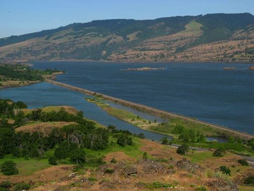
This is a short hike on an open scabland above the Columbia River with good views up and down the Columbia River Gorge. The plateau was scoured by the Missoula floods at the end of the last ice age, about 15,000 - 13,000 years ago resulting in a couple of kolk ponds (depressions resulting from swirling flood waters). Other features to observe are the low biscuit mounds on the plateau surface. Clifftop views let you see across to the mouth of the Klickitat River in Lyle and along the crest of the Columbia Hills in Washington. The area is most popular in spring (March through May), when wildflowers are in full bloom. Be sure to arrive early during those months. There are multiple jurisdictions on this small plateau: U.S. Forest Service, Oregon State Parks, and Nature Conservancy. Many people combine this hike with the one to Tom McCall Point. Please note that no dogs are allowed on these trails. From the Rowena Crest Trailhead, cross the highway and walk through the fence stile. A kiosk describes the uniqueness and fragility of the habitat here. A short spur to the left allows you to look down into the small canyon of Rowena Dell, with its private dwellings and tennis court. You'll hike an isthmus of sorts where the gently sloping Rowena Plateau narrows. The area is a floral paradise in spring, with lupine and balsamroot in the starring roles, but also including wild onion, bachelor's button, buckwheat, and popcorn flower. Next, a side trail heads off to the right to a great viewpoint looking east down to Salisbury Slough in Mayer State Park, while to the north is the town of Lyle at the mouth of the Klickitat River. You'll pass a trail coming in from the right, marking the top end of the Shasha Loop. Looking across the landscape of plateau, note the low hummocks of loess, often termed 'biscuit mounds,' basically heaps of windblown soil collected almost symmetrically over the entire surface of the plateau. Keeping left, you'll soon arrive at Rowena Pond, a kolk formation created during the Missoula Floods. The
Trail Stats
0.0 km
73 m
216 m
0 m
—
Photos

400px-RowenaPlateauMap
400px-RowenaPlateauMap
250px-RowenaPlateau2
250px-RowenaPlateau2

250px-Showy_downingia_%28Downingia_elegans%29%2C_Rowena_Crest
250px-Showy_downingia_%28Downingia_elegans%29%2C_Rowena_Crest

250px-Pacific_rattlesnake_infant_%28Crotalus_oreganus%29%2C_Rowena_Dell
250px-Pacific_rattlesnake_infant_%28Crotalus_oreganus%29%2C_Rowena_Dell

250px-Upper_pond%2C_Rowena_Crest
250px-Upper_pond%2C_Rowena_Crest

250px-RowenaPlateau1
250px-RowenaPlateau1

400px-Looking_east_from_Rowena_Plateau
400px-Looking_east_from_Rowena_Plateau