4 min
Overview
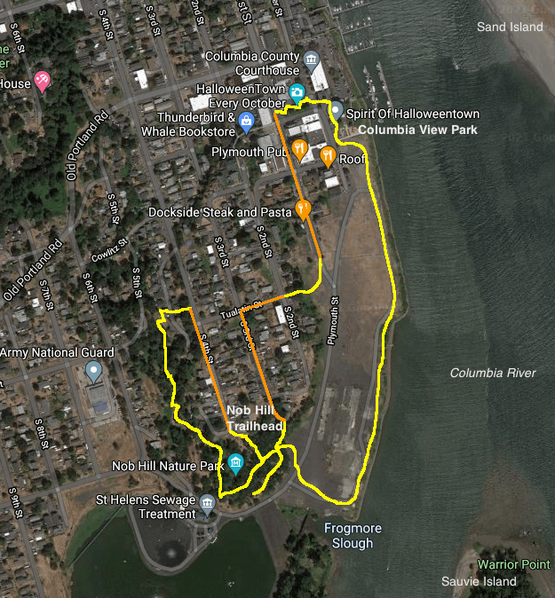
Mount Saint Helens sits low on the horizon but is visible from the its eponym, the county seat of Columbia County. This loop takes you from the 1906 courthouse across a wide open waterfront lot, once home to the Boise Cascade Veneer Plant, to get views to Warrior Point on Sauvie Island. Then you’ll tuck into the small trail system at Nob Hill Nature Park, an oak-wooded bluff that brims with wildflowers in the spring. Another trail, staircases, and quiet city streets take you back to the courthouse. From the parking area above Columbia View Park, find your way to the river, and walk south on a gravel path above the Columbia River on the currently (2021) open area that once housed a veneer mill. This 22-acre property was sold to the City of St. Helens in 2015 after the plant closed in 2008. There are big plans for developing the area, but a public riverfront path is part of the project. Across a channel is Sand Island, a public park accessible by boat only, and you should soon be able to make out Mount Saint Helens above the Washington shore, just north of the mouth of the Lewis River. The top of Mount Rainier can also be seen as well as the profiles of Silver Star Mountain and Larch Mountain. At the mouth of the Multnomah Channel, you can look across to Warrior Point, at the northern tip of cottonwood-forested Sauvie Island. Turn inland at an inlet known as Frogmore Slough. An old railroad drawbridge still spans this channel. Ahead you see a basalt bluff topped by oak trees. Walk to the right to find the entrance to little Nob Hill Nature Park – a painted 44-gallon drum here will guide. A set of steps leads up into this remnant natural area. At a junction, keep left to follow a path that gives a view over the St. Helens Sewage Treatment Ponds and further south to the old Boise Cascade pulp and paper mill, also now shuttered. Return to the junction, and bear left down a gravel trail. Oregon grape, camas, trillium, chocolate lily, and fawn lily bloom here in the spring. When you reach the kiosk on Plymouth St
Trail Stats
0.0 km
18 m
27 m
0 m
—
Photos
400px-StHelensWaterfrontMap
400px-StHelensWaterfrontMap

250px-Serviceberry%2C_Nob_Hill_Nature_Park%2C_St
250px-Serviceberry%2C_Nob_Hill_Nature_Park%2C_St

250px-View_to_Warrior_Point%2C_Boise_Cascade_Waterfront%2C_St
250px-View_to_Warrior_Point%2C_Boise_Cascade_Waterfront%2C_St

250px-Mt
250px-Mt

400px-Courthouse%2C_Plaza_Square%2C_St
400px-Courthouse%2C_Plaza_Square%2C_St